Snowdonia

We have used Ordnance Survey 3D data which is now freely available, to construct a section on the Snowdonian Mountain range. We have made the water level interactive so the user can enter a height and the water level will rise to that position. This is just one of the many uses the free OS data can be put to. It is extremely accurate and can be used for any geographical processes that require this level of detail. It allows us to show syllabus related content in actual environments. This is an example of the multimedia assets that can be integrated into the system. This is only a sample of the content available.


Click to enlarge
Teaching Geography in 3D
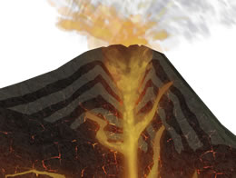 The study of geography stimulates an interest in and a sense of wonder about places around us in the physical world. It helps us make sense of a complex and ever-changing planet. It explains where places are, how places and landscapes are formed and how people interact with their environment. Gaia’s 3D Solution brings these places into the classroom, allowing students to investigate and discover our world. Read More